Spring Creek Trail Looks Worse Than I Thought
Last week the City of Richardson announced that they would be closing off portions of the Spring Creek Trail for repairs. Since I typically ride the west section, from the Routh Creek Parkway ramp to the Central Expressway underpasses, I didn’t know the extent of the wear and tear on the trail.
I took a spin thought the entire length this morning and discovered that it was much worse than I thought. Here are some pics of just a few areas marked for repair:
Seeing the extent of this wear makes me glad the city is working – proactively – to keep it maintained and safe for those using it. Yet, another great reason to live in Richardson.
Black Friday Ride Number 3 – November 25, 2011
It’s that time of year again. It’s the time to AVOID all the big crowds at the shopping mall, work off that Thanksgiving dinner and have a fun ride around town.
You are invited to attend Bike Friendly Richardson‘s third annual Black Friday Ride. Started three years ago as the inaugural ride that launched Bike Friendly Richardson, the Black Friday Ride gives folks an alternative way to kick off the holiday season. This is a casual paced ride that will explore many of the different route options available to Richardson cyclists. We will ride on back-roads, side-streets, multi-purpose trails and available bike lanes.
Come on out to the Shops at Eastside, enjoy a tasty lunch at Chiloso, Russo’s Italian Kitchen, Urban Eatz or Panera Bread, then meet us at the fountain around 1:00 pm. The route will be around 10 miles and goes through Spring Creek Park, where you can enjoy the colors of fall. We’ll end the ride back at the Shops at Eastside, where you can enjoy some tasty food or grab a cold one at Twisted Root Burgers.
DATE: Friday, November 25, 2011
TIME: Arrive: 1:00 pm, Ride: 1:30 pm
START/FINISH: Shops At Eastside – 700 E. Campbell Road @ Central (meet at the fountain)
PACE: Casual
RSVP: Via Facebook
ROUTE: Click Here (subject to change)
Comments Off on Black Friday Ride Number 3 – November 25, 2011
Spring Creek Trail Extension Officially Open

© City Of Richardson - (Council Members Amir Omar and Scott Dunn, Collin County Commissioner Cheryl Williams, Mayor Bob Townsend, Congressman Sam Johnson, Council Member Kendal Hartley, Mayor Pro Tem Laura Maczka and Council Member Mark Solomon)
If you’ve been following us for the past couple of years, we kept you updated on the progress of extensions of the Spring Creek Trail. These new extensions provide safe passages under Central Expressway and Renner Road.
This past Thursday was the ribbon cutting that officially opened the trail extension.
From the city newsletter:
City Council Members, staff and local officials celebrated the opening of the Spring Creek Trail extension at a ribbon cutting ceremony held Thursday.
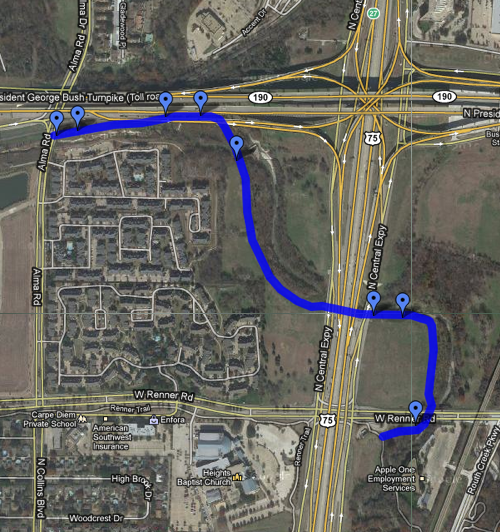
The new extension is a 1.3 mile, 12-foot wide concrete trail that extends the popular Spring Creek Trail north under Renner and US 75 and ends at Alma Road and the George Bush Turnpike. The trail also travels south following Prairie Creek under US 75 and then turns north to connect with the Renner Trail (see map below).
The wide, concrete trail accommodates multiple uses including walking, jogging, biking, strolling and in-line skating. Federal, state, county and local dollars helped to pay for the design and construction of the trail that allows users of the trail system a safe passage under busy roadways.
Quite frankly, after such a long time coming, we’re surprised that it was such an understated event. You’d think the city would be proud of it’s accomplishments and make a bigger P.R. event out of it. Regardless, it’s here and it’s open. Enjoy.
To see all the coverage of this trail extension development, click on the links below:
Spring Creek Trail – Including Under Central and Under Renner Road Connections:
Trail Construction – 03/11/2010
Under Construction-Two Bike Trails Under Central Expressway– 04/03/2010
More Trail Construction Pics – 05/08/2010
Trail Construction Moving Forward Nicely – 06/13/2010
Trail Construction Update Pics – 07/25/2010
More Trail Progress – 08/21/2010
New Guard Rail – 08/28/2010
More Trail Progress – Towards The Central Underpass – 09/26/2010
Central Underpass – Progress On The West Side – 11/28/2010
More Trail Progress – Retaining Walls Under US75 – 12/05/2010
Trail Under Central Progress – More Gabion Walls – 02/13/2011
Trail Under Central Progress – West Side Ramp – 03/06/2011
Spring Creek Trail: North Of Renner Road – A Progress Report – 04/02/2011
Trail Under Central – Serious Progress – 04/17/2011
Took A Ride Under Central Expressway Today – 04/23/2011
Updates To The Central Expressway and Renner Road Underpasses – 05/09/2011
Spring Creek Trail – Central and Renner Road Underpass Updates – 06/11/2011
Trail Under Renner Road – Progress – 07/28/14
More Renner Road Underpass Progress – 08/14/2011
Renner Road Underpass – Retaining Wall Progress – 08/27/2011
Major Progress With The Trail Under Renner Road – 09/18/2011
Trail Under Renner Progress – Forms Are Up, Cement Is Being Poured – 10/03/2011
Trail Under Renner Road Is Complete – 10/08/2011
Comments Off on Spring Creek Trail Extension Officially Open
They’re Closing The Gap Between Preston Ridge Trail and Cottonwood Trail
If you’ve ever tried to ride the Preston Ridge Trail from Richardson, Plano or even north Dallas into downtown Dallas, you might of found it a bit difficult. Sure it’s a good trail that leads towards downtown, but it falls short on Coit Road, between Belt Line Road and Spring Valley Road. The closest connections into town would be either the White Rock Creek Trail which begins at LBJ Freeway, just east of Hillcrest Road – or the Cottonwood Trail, which doesn’t begin until you go east on Spring Valley and south on Maham Road. Both routes would require you to leave the multi-purpose Preston Ridge Trail and navigate either streets or sidewalks to reconnect with the other trails. Easy for some, but not for less experienced riders.
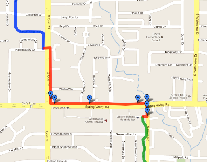
It looks like that’s about to change. We got a tip from a BFR friend that there is a new multi-purpose trail (which is part of the Cottonwood Trail) being constructed that will run along the east side of Coit Road, then along the north side of Spring Valley Road which will make the connection between the Preston Ridge Trail and the Cottonwood Trail. Great news for folks who don’t want to ride on the busy streets of Coit Road or Spring Valley Road.
It’s not a perfect solution. What qualifies this as a multi-purpose trail instead of a sidewalk? In this case, not much. Unlike other multi-purpose trails that run along the utility right-of-ways (like the Preston Ridge Trail), there isn’t much real estate to work with. Some would even think that this is no more than just a really wide sidewalk. They did the best they could with the limitations at hand. For that, we’re grateful.
We feel the best way to help differentiate this as a multi-purpose trail is to put a divider stripe down the center. This will indicate that it’s used for more than just a sidewalk. Also, put up signage to let people know what the intent for this trail is.
Click here or on the map above to get a closer look at the new connection. Below are some pics of how it looks so far.
Comments Off on They’re Closing The Gap Between Preston Ridge Trail and Cottonwood Trail
Spring Creek Trail – Central and Renner Road Underpass Updates
It’s been a few weeks since we’ve been on the Spring Creek Trail, so we thought we would share some updates.
Central Underpass (south of Renner Road)
Let’s start with the – almost complete – Central Expressway (US75) underpass, the one located just south of Renner Road. The last time we checked, all of the cement was poured except the small bit that connected it to the existing trail on the west side. We got an email on May 28th from BFR friend, Dennis, informing us that it was finally poured. Here’s a shot of that:
Some of the other improvements to this portion of the trail are new guard rails and painted retaining walls. These are the types of details that will make our trail system a nice place to travel – safe and visually pleasing. We’re glad the city has taken the steps to make these routes more than just utility.
Renner Road Underpass
The third and last holdout to the completion of the Spring Creek Trail underpass project is the section under Renner Road. This passage will be necessary to access the other Central Underpass, just north of Renner Road. Although behind schedule, quite a bit of progress has been made in the past couple of months. Now it looks like they’ve got a good start on a massive retaining wall.
Follow our coverage of the Spring Creek Trail extension
– Including Under Central Connections:
Trail Construction – 03/11/2010
Under Construction-Two Bike Trails Under Central Expressway – 04/03/2010
More Trail Construction Pics – 05/08/2010
Trail Construction Moving Forward Nicely – 06/13/2010
Trail Construction Update Pics – 07/25/2010
More Trail Progress – 08/21/2010
New Guard Rail – 08/28/2010
More Trail Progress – Towards The Central Underpass – 09/26/2010
Central Underpass – Progress On The West Side – 11/28/2010
More Trail Progress – Retaining Walls Under US75 – 12/05/2010
Trail Under Central Progress – More Gabion Walls – 02/13/2011
Trail Under Central Progress – West Side Ramp – 03/06/2011
Spring Creek Trail: North Of Renner Road – A Progress Report – 04/02/2011
Trail Under Central – Serious Progress – 04/17/2011
Took A Ride Under Central Expressway Today – 04/23/2011
Updates To The Central Expressway and Renner Road Underpasses – 05/09/2011
Comments Off on Spring Creek Trail – Central and Renner Road Underpass Updates
Pics From The 2011 Richardson WildRide!
I shared this on Suburban Assault, but thought I should share it here as well.
This past weekend, I decided to participate in the 8th annual Richardson WildRide! Against Cancer benefitting the Methodist Richardson Cancer Center, home of the Lance Armstrong Shaped Beam SurgeryTM program. The ride consisted of three distances of your choice – a 16 mile, 40 mile or 64 mile route. Last year, I decided to do the 16 mile route – mostly because I’m not a sports cyclist and I don’t have a proper road bike. It turns out the route was relatively easy and I finished rather early – even on my old clunker, mountain-to-road bike conversion. I told myself that I would do the 40 mile route in 2011.
As it turns out, I wasn’t able to get on the saddle as much this spring. Worried about not having enough training, I opted to do the 16 mile route again. Quite honestly, I’m shocked that there is such a gap between the short and medium routes. I would have preferred a 30 mile route.
At the actual line-up of the rally, I met some folks that were excited about doing the 40 mile route and getting to ride on the Lake Lavon Dam – only open to cyclists for this ride. I got motivated and decided to do the 40 mile route as well. Most of the ride was really nice and the scenery was amazing – even on such a cloudy and foggy morning. It wasn’t until the return stretch that I was regretting my decision to upgrade the route distance. Those small climbs up Shiloh and Campbell, that were so easy last year, seemed like mountains. Still, I managed to plow through and get my weak legs and heavy bike to the finish line. Of course I didn’t realize how tired I was until my 2.5 mile bike ride home from the event.
Here are some pics from the event. Click here to see the entire set.
Comments Off on Pics From The 2011 Richardson WildRide!
Spring Creek Trail: North Of Renner Road – A Progress Report
Do you remember when Bob reported about this trail over a year ago? Back then it was just an open field and a plan to extend the Spring Creek Trail from the Renner Road at Central Expressway rest stop to Alma Road at the PGB Tollway. We’re happy to report that, over a year later, the trail is mostly – and we stress mostly – complete. Unfortunately, two key portions that will connect it to the Spring Creek Trail are far from complete. Both the passages under Renner Road and Central Expressway still have a long way to go.
Like with the central underpass, just south of Renner, contractors didn’t quite make the goal of February 2011 completion. Considering how bad some of last winter’s snow storms were, the setbacks are understandable.
That didn’t stop us from taking a spin to investigate the progress. Check out some of the shots from the upcoming trail (Click on the map above to see these pics in context).
Some folks have questioned the purpose of this trail. Although it will provide a safe passage under Central Expressway, it really doesn’t provide much of a connection between east and west Richardson. Once it connects to Alma Road, it just stops. Well, according to the Richardson Bicycle-Pedestrian Trailways Plan, it will eventually continue along the PGB Tollway as well as the planned Cottenbelt Trail.
We’d like to see Dallas and Plano provide connections to both north and south Preston Ridge Trail. Fingers crossed.
Follow our coverage of this trail construction:
November 28, 2010
September 26, 2010
August 28, 2010
August 21, 2010
July 25, 2010
June 13, 2010
May 8, 2010
April 3, 2010
March 11, 2010
December 5, 2010
February 13, 2011
March 6, 2011
Comments Off on Spring Creek Trail: North Of Renner Road – A Progress Report
We’d Like To Address A Small Gap In The Central Trail Plan
We are very fortunate to have such an aggressive Bike and Pedestrian Plan in Richardson. The city planners are doing a great job retrofitting some new trails and bike lanes into an older, built-out infrastructure.
In that plan is the Central Trail, which will provide passage through Richardson. When completed, it will run through the central part of town, along the DART Rail Red Line, giving us, and all of our northern neighbors, a nice connection to the Dallas trail network.
Earlier this month, the City of Richardson presented the first draft of their plan to continue the Central Trail further south. Right now, the only existing part runs from Renner Road (patched through the Spring Creek Trail until it connects at Glenville Drive) to Arapaho Road. The new plan shows how the trail will continue from Arapaho Road, south towards Buckingham Road.
Although it’s a great plan, we feel that there are usability gaps within the existing part of the Central Trail that should be addressed as well. The following is our evaluation of the the part just south of Campbell Road and how we think it can be improved.
THE CURRENT TRAIL:
If you’ve walked or biked this part of the trail, you’ll be familiar with our references. Technically, the trail is complete from Campbell Road to Arapaho Road, which is why this section is not in the current extension plan. The concerns we have are with some minor aesthetics as well as some issues with usability that hinder the trail from being a complete success.
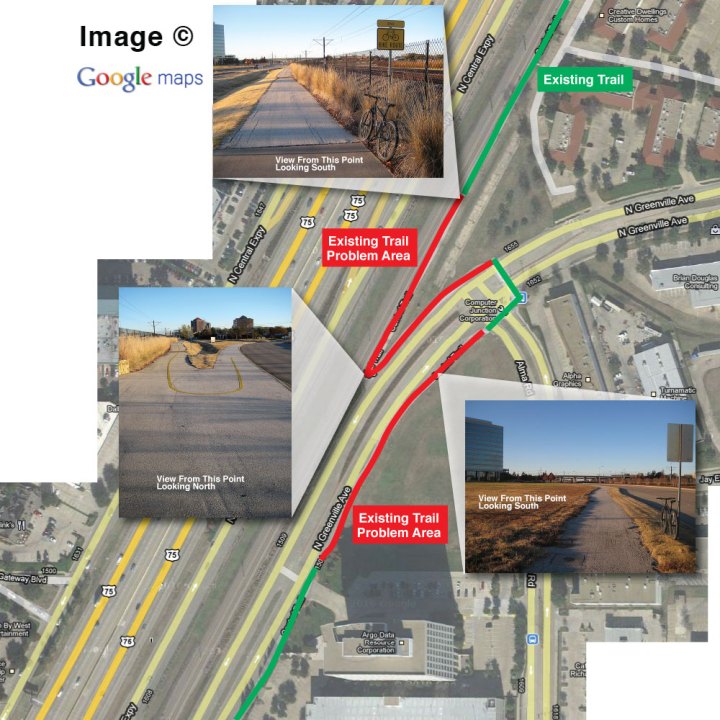
First, the minor aesthetics. About a third of a mile south from Campbell Road, you’ll note that the nicely paved trail ends. From there it becomes rough, narrow and overgrown with grass. This rough patch continues across and down the east side of Greenville Avenue until it reaches the Tecktronics parking lot at Collins Boulevard.
We realize that this is nitpicking, but if the City is spending the money to continue the trail, they should look into completing the trail experience by matching the rest of the trail.
Next is trail usability. Because of limited real estate next to the DART tracks, you can see why the trail jumps to the other side of Greenville Avenue. Since this trail leads to the DART Arapaho Station entrance, which is on the east side of Greenville Avenue, we’re okay with that. Considering the limitations in the existing infrastructure, we also understand how the trail runs narrow in some parts.
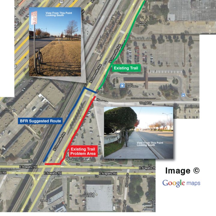
Our bigger concern is when the trail passes just south of the Arapaho DART Rail station. After the trail crosses Woodall Drive, it becomes a glorified sidewalk all the way to Arapaho Road. Here it’s too narrow for multi-use traffic. To make this worse, the shrubs along this part of the trail are overgrown and blocking even more space. In our opinion, this becomes a gap in the trail plan.
WE PROPOSE THIS SOLUTION:
Since the current plan to continue the Central Trail south from Arapaho Road starts on the WEST side of Greenville Avenue, perhaps we should look at crossing Greenville at Woodall Drive instead of Arapaho Road. This makes sense for a few reasons.
Let’s talk space. As mentioned, the limitations of real estate made sense to pull the trail to the east side of Greenville Avenue. This becomes less true at Woodall Drive. There is actually more space on the west side of Greenville Avenue at this point — plenty of space for a wider trail.
Let’s talk convenience. If you put a crossing at Woodall Drive and continue the trail from there, connecting the new new addition of the Central Trail (which is planned to start on the west side of Greenville Avenue) becomes more seamless.
Let’s talk safety. The current plan is to get trail traffic to cross the intersection at Greenville Avenue on the north side of Arapaho Road, and then cross Arapaho Road on the west side of Greenville Avenue. From experience, we know this to be an extremely busy intersection with lots of auto traffic coming from multiple directions. We feel that reducing the crossings at this intersections to just one would help with safety.
We realize that putting a crossing on Greenville Avenue, at Woodall Drive – an intersection not protected by traffic lights – might seem less safe. However, the trail already crosses Greenville Avenue – further north at Alma Road – under the same traffic conditions. If it’s safe enough at Alma Road, why not at Woodall Drive. In fact, we feel it’s easier for crossers to watch for auto traffic in just two directions instead of the many at Arapaho Road.
WHAT DO YOU THINK?:
Of course, this is all based on seat-of-our-pants, traveled experience on this trail and we haven’t pulled any statistical data that supports this as a better solution. We’d love to hear what you think about this. IF you’ve been on this part of the Central Trail, we’d like to hear your opinion on our solution and/or what you would do differently.
Click here to see a map.
Click here to see more shots.
Comments Off on We’d Like To Address A Small Gap In The Central Trail Plan
Central Underpass – Progress On The West Side
There is a bit more progress on the Spring Creek Trail / Renner Trail connection at the Central Expressway (US-75) underpass. This time there is progress on the west side of Central, extending the Renner Trail from where it dead ends at the QMAC building – to the upcoming under-highway connection.
Here is a quick pic of the east side (Spring Creek Trail connection) showing a bit more trail from our last report. From here, underpass construction will begin.
Follow our coverage of this trail construction:
September 26, 2010
August 28, 2010
August 21, 2010
July 25, 2010
June 13, 2010
May 8, 2010
April 3, 2010
March 11, 2010
Comments Off on Central Underpass – Progress On The West Side
Black Friday Ride Route Map
Tomorrow is looking to be a nice day for the Black Friday Ride. It’ll be sunny and cool so you probably won’t even break a sweat.
As a special treat, we’re working with Tripledub Images to help us capture the face of the Richardson (and Dallas) bike community. At one of our stops, Wendy will be taking individual pics of anybody who wants a photo with their bike.
For those of you who want to know the route in advance, here is a map of the ride. As promised, we will be experiencing all of the different types of routes available for Richardson cyclists: back roads, trails and bike lanes.
If you are on Facebook, let us know you are coming. I hope to see you at Fuzzy Taco Shop (561 West Campbell Road), tomorrow at 3:30.
Comments Off on Black Friday Ride Route Map
























Comments Off on Spring Creek Trail Looks Worse Than I Thought