They’re Closing The Gap Between Preston Ridge Trail and Cottonwood Trail
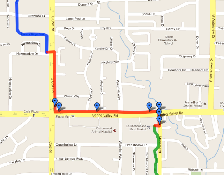
If you’ve ever tried to ride the Preston Ridge Trail from Richardson, Plano or even north Dallas into downtown Dallas, you might of found it a bit difficult. Sure it’s a good trail that leads towards downtown, but it falls short on Coit Road, between Belt Line Road and Spring Valley Road. The closest connections into town would be either the White Rock Creek Trail which begins at LBJ Freeway, just east of Hillcrest Road – or the Cottonwood Trail, which doesn’t begin until you go east on Spring Valley and south on Maham Road. Both routes would require you to leave the multi-purpose Preston Ridge Trail and navigate either streets or sidewalks to reconnect with the other trails. Easy for some, but not for less experienced riders.
It looks like that’s about to change. We got a tip from a BFR friend that there is a new multi-purpose trail (which is part of the Cottonwood Trail) being constructed that will run along the east side of Coit Road, then along the north side of Spring Valley Road which will make the connection between the Preston Ridge Trail and the Cottonwood Trail. Great news for folks who don’t want to ride on the busy streets of Coit Road or Spring Valley Road.
It’s not a perfect solution. What qualifies this as a multi-purpose trail instead of a sidewalk? In this case, not much. Unlike other multi-purpose trails that run along the utility right-of-ways (like the Preston Ridge Trail), there isn’t much real estate to work with. Some would even think that this is no more than just a really wide sidewalk. They did the best they could with the limitations at hand. For that, we’re grateful.
We feel the best way to help differentiate this as a multi-purpose trail is to put a divider stripe down the center. This will indicate that it’s used for more than just a sidewalk. Also, put up signage to let people know what the intent for this trail is.
Click here or on the map above to get a closer look at the new connection. Below are some pics of how it looks so far.


Comments Off on They’re Closing The Gap Between Preston Ridge Trail and Cottonwood Trail