Updated Pics Of The Central Trail (South) Construction
Here are some updated pics of the new, southern link to the Central Trail.


Construction is still looking a bit light, south of Belt Line. We’ll keep you posted on any new updates.
Central Trail Construction (South) Coming Along Nicely
We’ve been keeping an eye on the construction of the southern extension of the Central Trail.
Central Trail is the trail that runs parallel to Central Expressway, along the DART Rail Red Line tracks. Currently, it starts at Renner Road at Routh Creek Parkway (where it connects to the Spring Creek Trail), and runs south to DART’s Arapaho Center Station – well, sort of. In our opinion, it really stops at about Alma Road, and becomes a sidewalk, along Greenville, until it reaches Arapaho Center Station. Read more about that here.
This new addition is designed to extend Central Trail south, from Arapaho Road to Buckingham Road – at the city limit. Future extensions will eventually connect it to the White Rock Creek Trail. We were also given some information that lead us to believe that the trail extension will connect to the Arapaho Center Station train platform, instead of the bus transfer station on the east side of Greenville Road. That would be fantastic if it actually happens.
Once this extension is complete, people will be able to walk or ride their bikes to three of the four DART train stations in Richardson (Spring Valley, Arapaho Center and Galatyn Park). The Bush Turnpike Station will have to wait for a future extension.
Here are some pics and descriptions of the current progress:
This shot was taken at the southwest corner of Arapaho Road And Greenville Avenue. You can see the DART tracks to the right and Greenville Avenue to the left.

This shot was taken a bit further south along Greenville Avenue. As you can see, they’re making every effort to save the trees.

This shot was taken even further south along Greenville Avenue. Here you can see how the trail will coexist with the DART Red Line.

This pic was taken just south of the Jackson Street crossing.

As you can see, the trail isn’t ready to ride.

As the trail approaches Belt Line Road, it actually crosses under the DART Rail track overpass.

This is where the trail will cross Belt Line Road. The city has decided that the light at Interurban will be the best place to cross.

Once across Belt Line Road, the trail is lost at this parking lot entrance. It eventually begins again at the rail underpass.
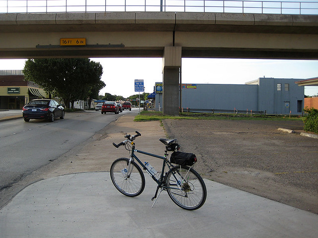
The trail construction seems to end at Polk Street.

I rode a bit further south to find this bridge being built at Phillips Street. Not seeing a current plan, I can only guess that this will have a roll in the extension of Central Trail.

I didn’t get a chance to ride down to Spring Valley Station. I’ll try to get down there next weekend to check on any progress down there.
Comments Off on Central Trail Construction (South) Coming Along Nicely
Richardson City Council Awards Bid for Central Trail Construction

From the City of Richardson weekly newsletter:
The City Council on Monday awarded a bid of $3.4 million to Ed Bell Construction Company to extend the Central Trail 1.9 miles from the Arapaho Road DART Station to the southern city limit. Construction of the 10-foot wide concrete multiuse trail is expected to begin in April and last for about one year.
The $4 million project is funded through Dallas County and the City of Richardson’s 2010 Bond Program. The lowest bid to construct the trail came in about $400,000 over budget, so the City removed some amenities such as irrigation systems, landscaping, and benches to be constructed in a possible second phase at a future date. The City also hopes to use $600,000 in Regional Tollway Revenue funds awarded for the Central Trail to help enhance the project.
The Central Trail currently runs from the Spring Creek Trail in north Richardson and ends at the Arapaho Road DART Station. The extension will run alongside the DART rail line and is planned to eventually connect with the Richardson city limit to the south and a future connection to the Dallas’ White Rock Creek Trail.
Watch the City Council presentation at http://bit.ly/V6oiYQ.
We are extremely excited that this is happening and we’d still like to see the small gap in the plan addressed.
Comments Off on Richardson City Council Awards Bid for Central Trail Construction
Help Plano See the Light
By bergerandfries
All, Plano is looking at putting in a traffic signal at Preston Road and Commonsgate where Bluebonnet Trail could cross Preston. In order to do that, they have to do a traffic signal warrant study. Both vehicular traffic on Preston and bike/ped traffic on Bluebonnet at Preston will be counted. A signal can be warranted based on the volume of vehicular traffic (which we easily have), and/or volume bike/ped traffic. Get the picture?
When?
Wed 10/31 from 1 pm to 7 pm
Thurs 11/1 from 7 am to 1 pm
What?
You need to travel West/East on Bluebonnet and turn around in the gas station parking lot (RaceTrac or QT) and head back East/West during the above windows of time.
I will leave 2400 Glenville Drive at 4:00pm on 10/31 to go to this intersection, and will ride from this intersection back to 2400 Glenville Drive starting at 7:30am on 11/1 if anyone wants to join me!!!
Comments Off on Help Plano See the Light
Richardson City Council Receives Update on Central Trail

From the City of Richardson‘s weekly newsletter:
The City Council received an update Monday on the extension of the Central Trail, which runs from the Spring Creek Trail in north Richardson and currently ends at the Arapaho Road DART Station. Plans call for the trail to extend to Richardson’s southern city limit and eventually connect with Dallas’ White Rock Creek Trail.
The City expects to begin construction on the trail in January and complete the project in early 2014. The 1.9-mile extension will cost $4 million and is funded through Richardson’s 2010 Bond Program and Dallas County.
Watch the work session presentation at http://bit.ly/P8H54b.
We’re pretty excited about this extension and what it would mean for connecting the east side of Richardson to the White Rock Creek Trail (although the current plan doesn’t extend that far, just yet). This would make commuting into Dallas – via multi-purpose trails – pretty easy.
We still have our reservations of how the trail is planned just north of Arapaho, connecting to the Arapaho DART station and the existing portion of the trail to the north. So far, it’s just a narrow sidewalk and there are no plans to re-route or widen it. Click here to see our post on this.
Comments Off on Richardson City Council Receives Update on Central Trail
Bike Lane Update
From the City Of Richardson‘s weekly newsletter:
The City Council received an update on efforts to expand the Bike Transportation Program in Richardson at its work session on Monday. The City is among many other municipalities and organizations in North Texas working to provide more bike lanes and improve safety for people who commute by bike. Many of these bike routes are designed to connect across the region when complete.
Expanding Richardson’s bike lane system and enhancing pavement markings and signage is one of the City Council’s near-term goals. Ten miles of a planned 20 miles of bike lanes have been installed, including lanes on Custer Parkway, Grove Road and Waterview Drive. Additional lanes funded through the Safe Routes to School grant are expected to be complete in 2013 along Collins Boulevard from Plano Road to Jupiter Road, Yale Boulevard from Arapaho Road to Campbell Road, and Owens Boulevard from Woodoak Drive to Campbell Road. The Duck Creek Trail Extension will add a route in 2014 along Collins Boulevard from Plano Road to US-75.
The City has installed signs identifying bike routes in Richardson and is working to clearly mark them on roads to improve safety. City officials will continue to work with bicycle organizations, including local partner Bike Friendly Richardson, and neighborhood groups to identify and implement additional bike routes.
Watch the Bike Transportation Program presentation here.

Comments Off on Bike Lane Update
Proposal for Regional Trail Connection at Breckinridge Park
From the City Of Richardson:
The City of Plano is partnering with the City of Richardson to plan and construct a 1.9-mile trail that would wind through Richardson to connect an existing trail in southeast Plano to the Timbers Nature Preserve Park in Murphy. The trail is completely funded through the City of Plano’s bond program. The City of Richardson would provide the land and future maintenance of the trail if the City Council approves an Inter Local Agreement at a future meeting.
The trail is proposed to be built in two phases, with Phase 1 running from the west side of Murphy Road within an Oncor high transmission line corridor to the existing trail on Rowlett Creek in Breckinridge Park. Construction on this part of the trail is expected to take place in 2013. Phase 2, which is currently unfunded, would connect Rowlett Creek to Otto Middle School. The City of Plano hopes to receive a grant from Collin County to pay for additional trail length, which is set to be constructed in the next two to three years.
Watch the work session presentation at http://bit.ly/Pr38zq.

Comments Off on Proposal for Regional Trail Connection at Breckinridge Park
Spring Creek Trail is Re-Opened

According to this week’s newsletter from the city:
Repair work on Spring Creek Trail has been completed by the contractor ahead of schedule, and other than some cleanup work still taking place over the next several days, the trail is open for all users once again.
The trail was closed in three phases beginning Jan. 3, and the rehabilitation work along the 1.1 mile section had been expected to last until Feb. 7. The City contractor removed and replaced concrete trail sections that had been damaged by tree roots and shifting soil.
Comments Off on Spring Creek Trail is Re-Opened
New Bike Route Signs On Collins
I noticed these last night and thought I would share. The new signs – that I’ve seen so far – are placed on Plano Road (approaching Collins) and on Collins, between Plano Road and the Central overpass.
I wonder if these are place holders until they get money to finish out the painted bike lanes on Collins.

View From Plano Road Facing South (to Collins intersection)

View of Collins - Westbound
Comments Off on New Bike Route Signs On Collins
Plano On-Street Bicycle Signs and Routes
Hello there, bergerandfries with my first BFR posting. Our friends in Plano have kicked off a project to make Plano easier to ride by bicycle! Plano has a great off street Multi-Use Path system, but now they are implementing On-Street bicycle signs and routes.
A map can be found at here (pdf).
An excerpt from Plano’s Website at: City of Plano’s On-Street Bicycle Routes
What will the signage be?
The signage is in accordance with the Texas Manual for Uniform Traffic Control Devices, a code that regulates traffic signage at the state level, ensuring that all traffic signage is consistent. This code also dictates how signs are placed in terms of location and frequency and how they are displayed. Most of the signage is green and white guidance signage. This regulatory sign below tells both the cyclist and the motorist that the cyclist has the right to occupy the whole travel lane.

Guidance signs show the Plano logo, a bicycle symbol and the route number you are on. Some directional signs show which way to turn to intersect with another bicycle route.


What do the numbers mean?
For example, the numbers 90, 88, 70 and 37 above are route numbers. The routes are numbered because they are often not one single through street but a combination of several different streets making up the route.
The numbering system mimics our nation’s interstate highway system. Odd numbers indicate north-south routes. The odd numbers are smaller on the west side of the city increasing as you move eastward starting with 5 and ending with 97. Even numbers indicate east-west routes. The even numbers are smaller on the south side of the city increasing as you move north starting with 2 and ending with 90.
What can Richardson folks do to help?
Plano Bike Route #97 leads directly into Richarson North Star Rd, which on the Richardson Bike Plan is a future signed on-street route too. You might remark to City of Richardson that it’s time to get moving on North Star Rd marking. These signs can really helps Richardson folks to get around Plano if they don’t know the best places to cycle on-street. And if you stop in any Plano businesses, even if the signs are not up yet, please thank them for being on the Plano Bike Route #xxx and ask when are they getting a bike rack!
Comments Off on Plano On-Street Bicycle Signs and Routes


Comments Off on Updated Pics Of The Central Trail (South) Construction